Overview

We want to know what you think of proposals to change the traffic regulation order (TRO) in an area east of Halifax town centre. The area connects Halifax Rail Station, The Piece Hall, Woolshops, Halifax Bus Station, Broad Street Plaza and routes in and out of the town centre. We will use feedback from this informal consultation to ensure plans for this section of the A629 phase 2 Halifax town centre project are ready to be submitted for a formal TRO consultation later in the year.
We're listening...
We are seeking further feedback to help us shape and refine the proposals.
Review the proposals
Please take some time to review the proposals and let us know if you have any questions or feedback.
Send your feedback
Email your feedback to A629phase2tro@calderdale.gov.uk
Printed copies of the A629 phase 2 Halifax town centre informal TRO east area consultation are available on request.
Project aims
- Economic growth, new investment, greater footfall, and more trade.
- Public spaces for people, trees, landscaping, and improving the aesthetic appeal of Halifax.
- Sustainability, routes that prioritise walking, wheeling or cycling around the town centre, and easier access to Halifax Rail Station and Halifax Bus Station.
- Safe journeys for all.
- Shorter journey times, less traffic through the town centre particularly at peak times, and alternative routes to the east and west of town.
- Improved air quality.
We are consulting on these proposals from Friday 14 February until Friday 14 March 2025.
Proposals
The full set of proposals is available on one plan that you can view full size or view as a PDF.
Summaries of sections of the proposals (below) provide detail at a scale that may be easier to view on smaller screens.
Image: A629 phase 2 Halifax town centre informal TRO east area (view full size)
Charlestown Road (TRO-001 and TRO-002)
We're proposing to extend the outbound lanes on Charlestown Road to increase the capacity of the junction of Charlestown Road and New Bank and reduce congestion at peak times.
We propose to improve pedestrian crossings between New Bank and North Bridge.

We propose resurfacing the road and upgrading the crossing between the two roundabouts with signals.

Winding Road (TRO-003)
We propose a new bus layby south of the Wade Street junction with Winding Road, to allow bus passengers another option for access to the town centre before services terminate at the Bus Station.
Improvements to crossings and junctions on Winding Road will make travel through this area safer for everyone.
We are also proposing a new shared cycleway / footway on Winding Road (Bus Station side), to allow safe routes for people walking and cycling to and from Broad Street and North Bridge.

Charles Street (TRO-004)
We are proposing to add a bus gate between King Street and Square Road to limit access to Charles Street for buses, coaches, cycles, taxis and motorcycles only.
We are proposing parallel zebra crossings for pedestrians and cycles to link Winding Road and the rail station.

Bank Bottom (TRO-005)
We're proposing to change the layout at the junction of Church Street, Lower Kirkgate and Bank Bottom to improve routes on the eastern side of the town.
The new layout will provide right-turn lanes leading to the retail delivery entrance and Southowram Bank. These lanes will mean heavy goods vehicles will avoid having to stop-start on the hill, and improve traffic flow along Bank Bottom.
We're proposing to add crossings on each arm of the junction so that people can cross safely, and add landscaping.

Eastern gateway (TRO-006)
We propose to open the old route along Church Street to the eastern side of the former warehouses at 31 Square Road, known as the Hughes Corporation building, as the main road east of Halifax town centre.
We are proposing a new public space outside key Halifax visitor attractions, to welcome visitors arriving from the rail station, and to provide a safe walking and cycling route into the town centre.
The proposals will create a bus hub linking the rail station, bus station and key attractions.
Rising bollards are proposed to control access to the pedestrianised area for vehicles.
The proposals include landscaped areas and space for future artwork.

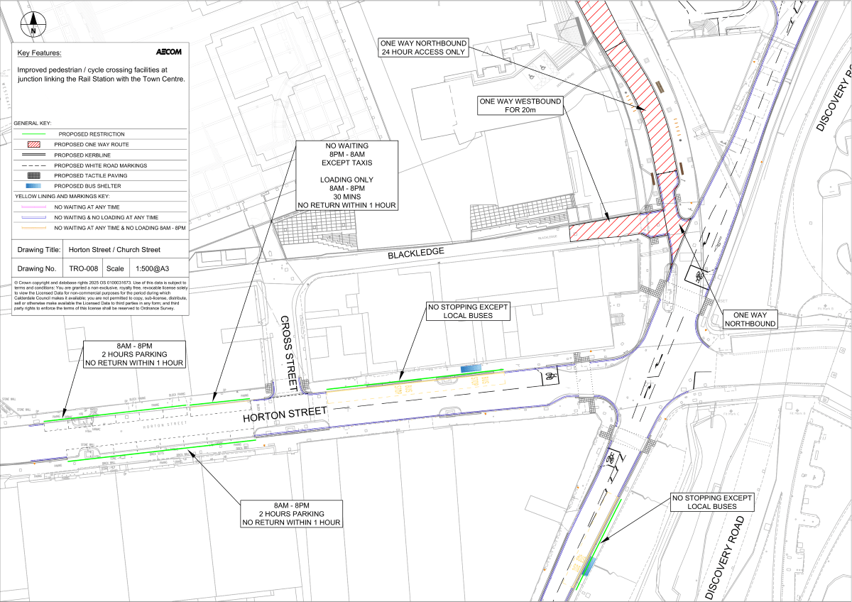
Horton Street and Church Street (TRO-007)
We propose to improve crossings around the junction of Horton Street and Church Street to provide safer links between the rail station and the town centre.
New Road and South Parade (TRO-008)
We propose to replace the mini-roundabout at the junction of Prescott Street, South Parade, New Road, and Church Street with a signalised junction.
New crossings and cycle routes through the junction will provide safer links between Halifax and places south of the town centre.
We propose to close New Road to vehicular traffic at the junction with Prescott Street to reduce the number of roads that will meet at the junction.
It is proposed that there will be no access out of Lilly Lane into the junction. Access to Lilly Lane will still be possible.
